splash image

Selected reference projects


Consultancy on Minimum Environmental Flow and Regulations for Hydropeaking Regimes for Bakaru Hydropower Plant Indonesia, ID


Client:

Tractebel Engineering GmbH

Background:

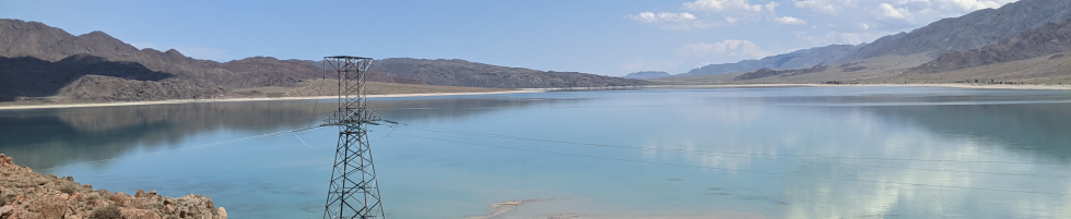
The Mamasa river in Sulawesi, Indonesia has been affected since the 1980s by the water diversion caused by Bakaru I HPP and in addition by water level fluctuations downstream of the tailrace outlet following hydropeaking operation. No environmental flow regulation has been in place and therefore only higher flows exceeding the turbine capacity had to be released into the dewatered reach. Because such events occur regularly and frequently and because of the highly diverse riverbed morphology some fish and other aquatic species found suitable living conditions despite the severe impact from hydropower. However, the species composition is significantly more diverse, and the biomass is much higher outside of the dewatered reach. Additionally, the power plant Bakaru II is under construction which is making use of the same intake and reservoir. The installed capacity will be roughly doubled and the flow of water which is diverted into the turbine intakes will also be doubled in the future. Therefore, the period and frequency in which natural spill occurs at the diversion dam will be significantly reduced and the hydropeaking impact will be significantly stronger. In parallel to the addition of a second hydropower plant there will be new ecological requirements, particularly E-Flow releases at the dam and certain limitations for the hydropeaking operation.

Descripton:

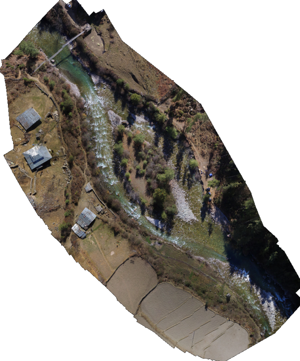
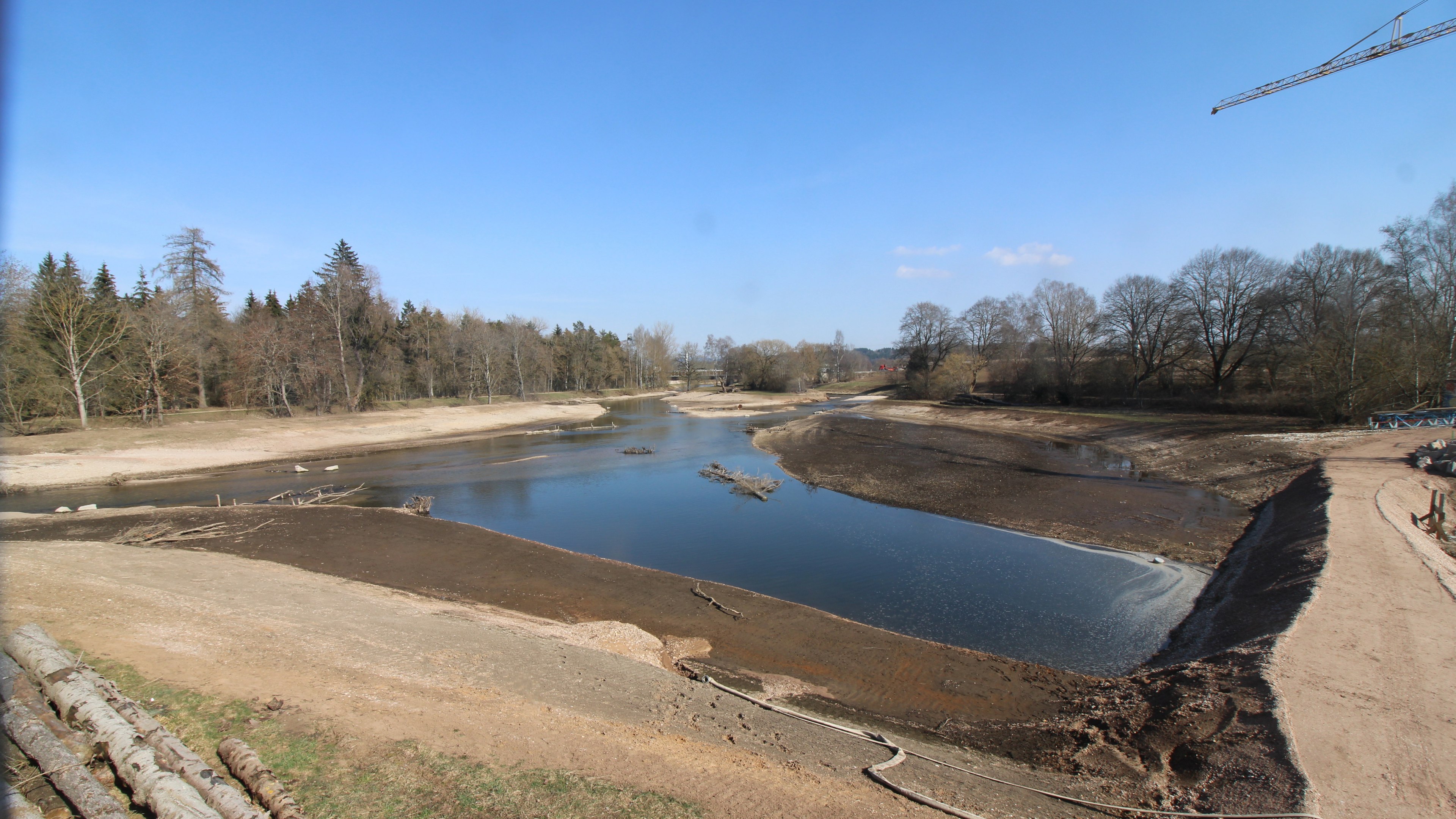
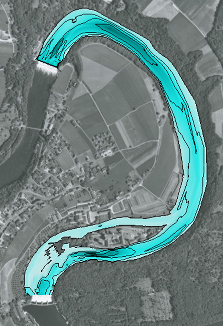
To achieve the base information for environment-friendly hydropower operation at the Bakaru HPP, four stretches within the affected river reach have been investigated. 
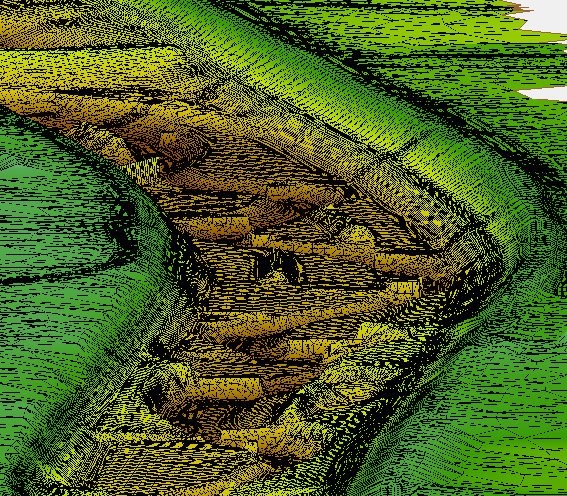
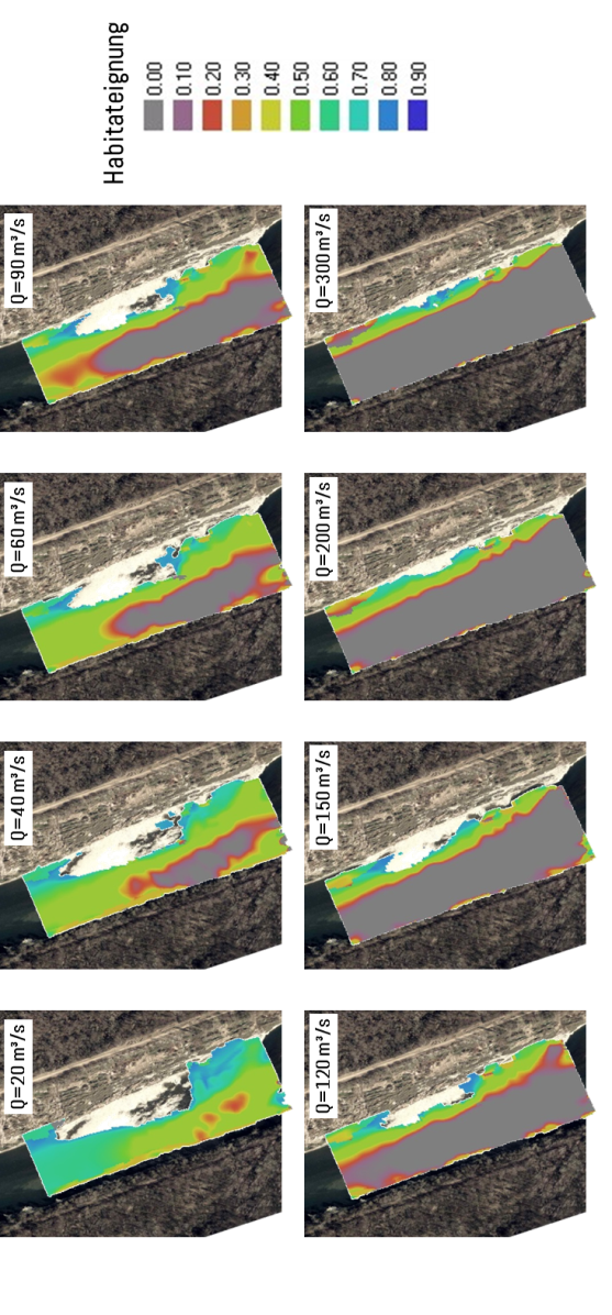
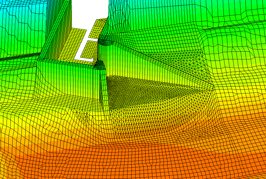
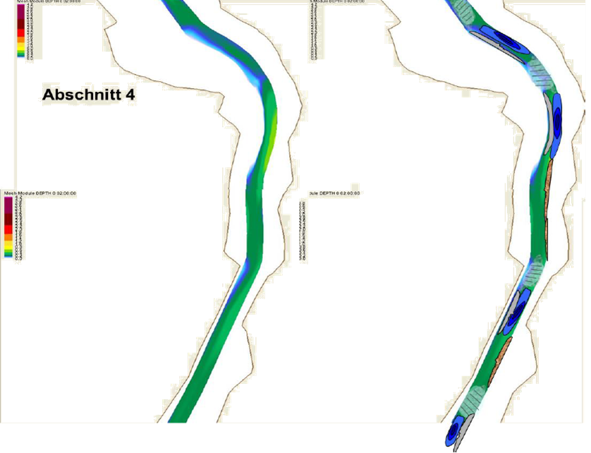
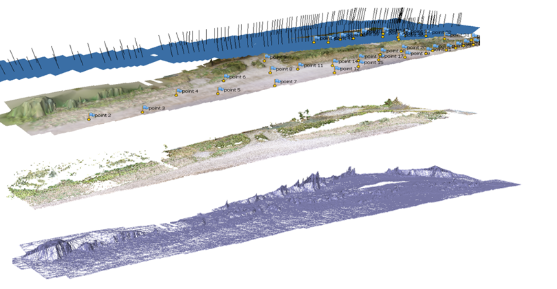
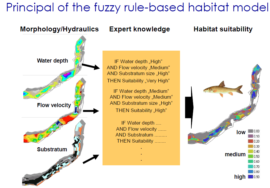
Fishing campaigns, terrestrial survey, sampling, gauge installation, drone flights and mapping were part of the data collection. With the collected data hydrodynamical-numerical 2D 
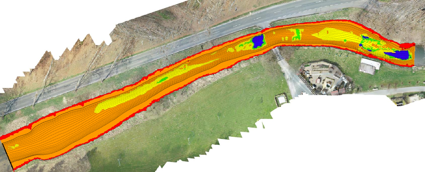
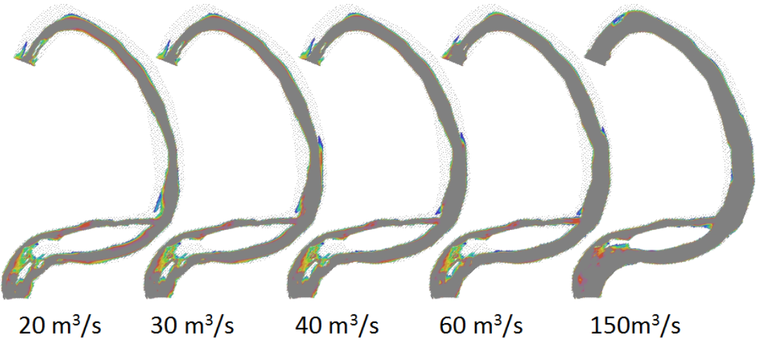
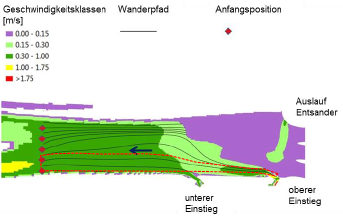
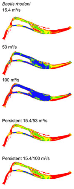
modelling and habitat modelling (CASiMiR Fish) has been performed. In a second step hydropeaking (CASiMiR Hydropeaking) and its effect on the present fish species have been investigated and analysed.
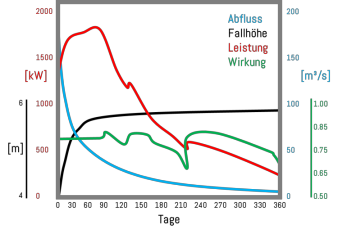
Based on the results of habitat and hydropeaking modelling, E-Flow regulations and hydropeaking operation were recommended for the additional Bakaru II hydropower installation. They are part of a hydropower operation with mitigated impact on the ecology of the affected Mamasa River.


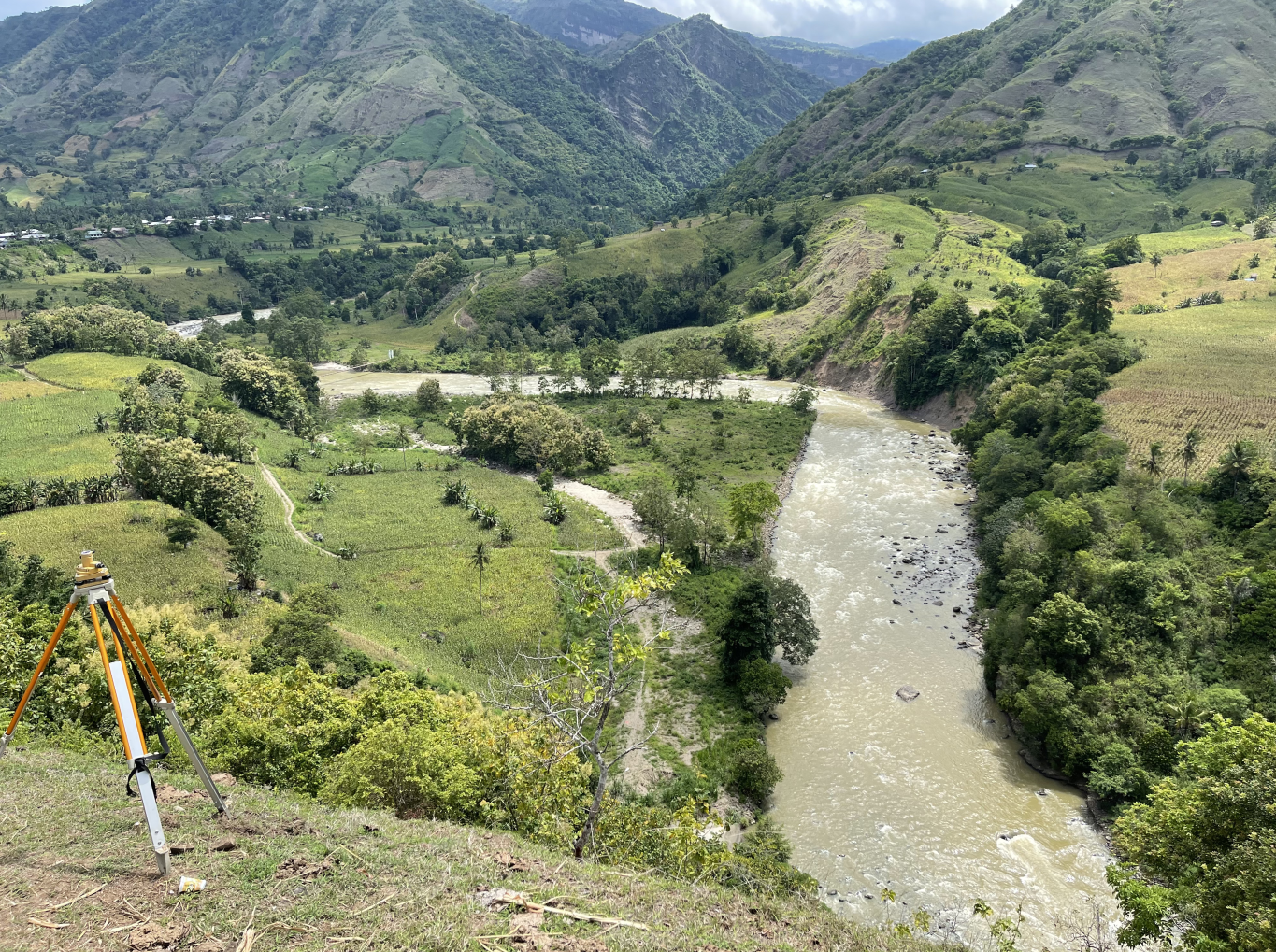
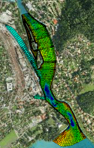
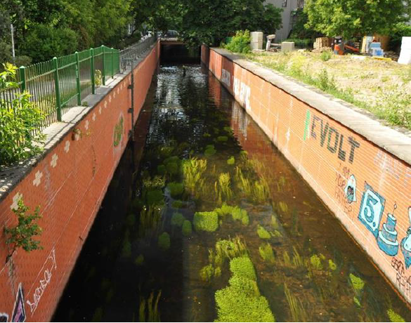
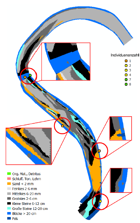
Investigated reach in Mamasa River


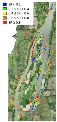
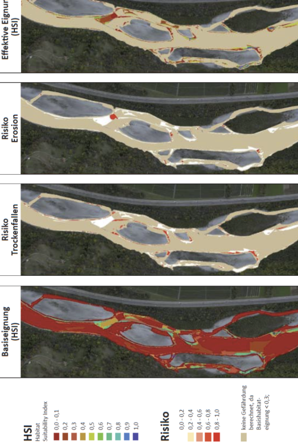
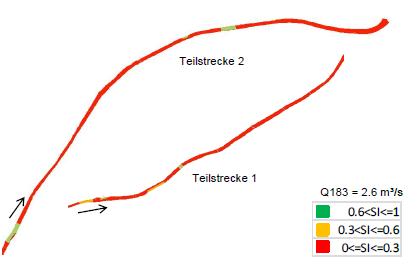
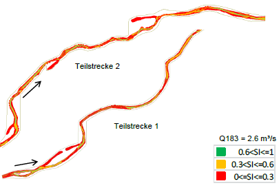
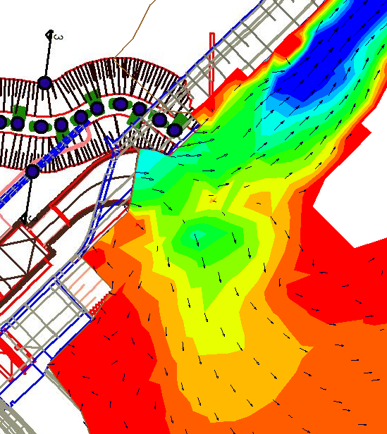
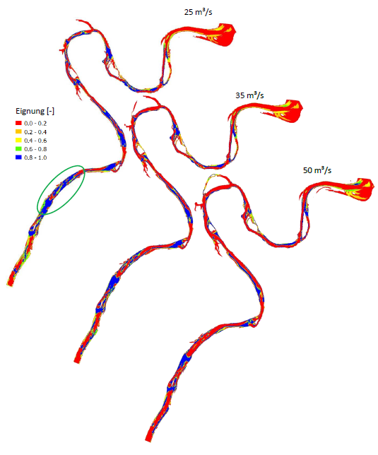
Calculated stranding risk during hydropeaking scenario

↑ up

Study on Minimum Environmental Flow for Hydropower Projects in Bhutan, BTN


Client:

Royal Government of Bhutan - National Environment Commission

Background:

Hydropower is one of the most important natural resources in Bhutan with a potential of more than 30 GW. The development of these natural resources is a key to supply energy for Bhutan’s economic development. To conserve the ecological integrity of the aquatic ecosystems and river corridors, environmental flows and fish migration are of major importance. However, environmental flows as they are presently recommended in environmental impact assessments for the hydropower development in Bhutan are in strict contradiction with conservation goals for natural habitats and wildlife in the Kingdom of Bhutan. They do not meet international standards and will result in a dramatic decline of affected riverine ecosystems.
Aim of this consultancy work is to develop detailed recommendation measures and an action plan which could be adopted immediately by the corresponding Bhutanese authorities. A guideline is developed which describes in detail the procedures and methods to be applied to all diversion-type run-of-river hydropower projects to determine environmental flow regulations appropriate for the protection of fluvial aquatic ecosystems and river corridors in the country.

Descripton:

Based on four pilot reaches in four different river systems an action plan and guidelines on how to determine environmental flows in Bhutan is developed, taking all different disciplines into account. SJE Ecohydraulic Engineering GmbH takes part in data mining, terrestrial survey, hydrodynamic-numerical modelling, habitat modelling and capacity building with the staff of the local Bhutanese authorities.
In phase 2 of the project the focus is on the institutionalization of training and capacity building for Bhutanese experts. For that purpose, E-Flow modules with different topics are developed to be integrated into existing academic frameworks and curricula at the College of Science and Technology (CST), Ugyen Wangchuck Institute for Conservation and Environmental Research (UWICER), and College of Natural Resources (CNR). Course materials are set up and a pilot implementation of the course modules is performed in close collaboration with academic staff at the respective institutions and consulting partners in Bhutan.


Pilot reach in Parochhu River


Course participants 2022

↑ up

Impairment of Fish Habitats in the Wiesent River Due to Canoeing/Development of a Management Concept, GER


Client:

Bezirk Oberfranken, Germany

Background:

The Wiesent River as one of the last remaining rivers with a good population of European Grayling (Thymallus thymallus) in Bavaria - runs through the culturally and geologically attractive region Fränkische Schweiz in Upper Franconia. Along the Wiesent’s river course canoeing is popular and there are several commercial canoe rental companies. Depending on the discharge situation and especially during the low water periods in summer, which have become more and more frequent in the recent years, canoeing can cause considerable disturbances of the local fish fauna.
Aim of the presented study is to investigate the impairment of fish habitats by boats at different flow conditions. Based on the gained knowledge a management concept is developed, taking the various and partly conflicting interests of river users and river ecology into account.

Descripton:

In order to assess the impairment of fish habitats by canoeing, surveying and mapping in different stretches of the Wiesent river were carried out. Based on this field data, hydrodynamic numerical models were set up and the habitat simulations for typical riverine fish species were performed with the habitat model CASiMiR Fish. Electrofishing and mapping of the caught fish were used to validate the results of the habitat model in all in all 9 different river reaches.
To finally assess the habitat disturbance due to canoeing, canoe paths were predicted by the application of an agent-based model . Modelled habitats and canoe paths were overlayed to identify areas with the highest conflict potential. By an approach considering the a depth-dependent reduction of habitat suitability caused by interfering boats the intensity of disturbance has been quantified. The investigations were performed for different discharges in order to develop flow-dependent regulations. Based on the findings, a management concept has been developed, that enables canoeing on the Wiesent river with significantly reduced impacts on the river-type specific fish community.


Overlay of grayling habitats and modelled canoe paths for a discharge


Underwater monitoring of fish behaviour during canoe passage

↑ up

Ecologic Restoration of the Danube at the Confluence of the Rivers Brigach and Breg,GER


Client:

Regierungspräsidium Freiburg, Freiburg, Germany

Background:

Due to straightening and morphological modifications, the rivers Brigach and Breg are heavily degraded in the area of their confluence at the source of the Danube river in Donaueschingen, Southern Germany. Because of this degradation habitats for the typical riverine fish species are rare or have disappeared. The presence and population density of these species on the other hand is a necessary requirement to reach the good ecological status according to the European WFD. For the sustainable enhancement of the habitat conditions, morphological and structural measures are implemented. In addition, these measures are intended to maintain or to improve flood protection.

Descripton:

To investigate the effectiveness of the morphological restoration, hydrodynamic-numerical models were created for the status quo and the future situation after implementation of the restoration measures. For modelling the future situation with implemented measures, it is not the situation after construction work, but after first morphological developments that is taken into account by the application of morphodynamic calculations. Based on the results of the hydro- und morphodynamic models, habitat modelling has been performed for the typical riverine fish species. On the basis of the habitat model results the ecological effectiveness of the river restoration can be assessed.
With the following three webcams the current construction progress can be viewed.
Webcam 1

Webcam 2

Webcam 3

Sectin of the hydraulic model - river Breg with implemented measures


River mouth of river Brigach during construction

↑ up

Ecohydraulic investigations in the diverted reach of the hydropower plant Rheinau, High Rhine, CH


Client:

Rheinaubund, Schaffhausen, Switzerland
Bundesamt für Energie, Bern, Switzerland

Background:

Two weirs in the diverted river reach of the Rhine near Rheinau, which dam up the water level of the residual discharge to the one before the construction of the power plant at mean flow, prevent the development of a near-natural discharge pattern. The concession of the hydropower plant will expire in 2036, but according to the Swiss Water Protection Act diverted reaches of hydropower plants have to be reconstructed. The planned revision of the turbines and the resulting higher discharges in the diverted reach were the cause to investigate the local conditions and define potential enhancement measures. Objective of this project was to determine guidelines for the reconstruction of diverted river reaches according to the Water Protection Act.

Descripton:

SJE conducted different enhancement measure scenarios for the hydropower plant Rheinau, High Rhine. With the simulation model CASiMiR, habitat simulations were performed for fishes and benthic macroinvertebrates, considering different structural and hydraulic boundary conditions. Retreat of the weirs, creation of ramps, islands and gravel banks as well as the variation of discharge were taken into account. In addition the impact of a turbine and a morphological redesign of the “Chly Rhy” were investigated. Furthermore animations, showing the landscape for changing water surface elevation were generated. An animation of a simulated scenario can be watched here

Spatial distribution of habitats, grayling adult

Spatial distribution of habitats, larvae nases, scenario B3-M2

↑ up

Ecological impact of flood protection measures at the river Aare, outflow Lake Thun, CH


Client:

EAWAG - Eidgenössische Anstalt für Wasserversorgung, Abwasserreinigung und Gewässerschutz, Kastanienbaum, Switzerland

Background:

The flood event in May 1999 showed again, that Lake Thun has an insufficient discharge capacity in certain meteorological situations and is not able to divert the inflow. Therefore the Department of Water- and Energy Management of the canton Bern investigated a potential increase of the outflow cross section by lowering the Aare river bed at the outflow of Lake Thun. Thus the discharge conditions could be improved and the risk of flooding for the city of Thun could be reduced. Different alternatives of dredging were investigated hydraulically and evaluated concerning their discharge capacity. One of the main objectives of the ecological investigations was the disturbance of the valuable grayling spawning habitats at the outflow of the lake.

Descripton:

SJE investigated the spawning habitats at the outflow of Lake Thun with colleagues from EAWAG. At first a hydrodynamic-numerical 2D model was set up. Based on the substrate information sampled in field measurements, discharge measurements and mapping of the spawning habitats, predictions about the potential spawning habitats were generated with CASiMiR. These predictions provided statements about the effects for different dredging variants and thus recommendations to preserve the spawning habitats of national importance.

Hydraulic modeling grid, Aare at the outlet of Lake Thun

↑ up

Minimum flow investigations, Environmental Impact Assessment hydropower plant Kembs, Upper Rhine, FR


Client:

EdF – Electricité de France, Kembs, France

Background:

In the context of the relicensing of the hydropower plant Kembs, Canal d’Alsace, operated by EdF, one of the main objectives was the establishing of an ecological minimum flow. The Canal d’Alsace is labeled with a major significance to the repopulation of Atlantic salmon. Therefore a key factor of the future flow regulation was the provision of suitable spawning habitats for Atlantic salmon. Furthermore the preservation of the existing valuable breeding grounds and pioneer locations were objective of this project.

Descripton:

In the approx. 40 km long diverted river reach of the Upper Rhine, ecohydraulic simulations were performed for 5 different reaches. The objective was to investigate discharge-dependent variations of the fish habitats, especially for the target species Atlantic salmon. The calculations were based on field measurements, sampling the geometry and morphology in the different reaches. Furthermore measurements of water surface elevations and discharge were conducted to calibrate the used hydrodynamic-numerical 2D-models. Water depth, flow velocity, wetted area and derived from that the habitat conditions could be determined for any discharge, resulting in an optimized flow regulation adapted to the course of the year. A 1d model was set up for the whole 40 km stretch and used to determine the impacts of the discharge variations in the whole stretch.

Results of the CASiMiR module for different discharges

↑ up

Efficiency assessment for modernization of hydropower plants, hydropower plant Nachrodt, Lenne, GER


Client:

Private Operator, Nachrodt, Germany

Background:

The mean annual working capacity of the hydropower plant Nachrodt, Lenne, was significantly lower than the technical potential. Like in many other cases the reason was a non-automated operation and the wear and tear of turbines and generators. Furthermore losses, because of non-operating periods due to damages of the hydropower plant, were responsible for the reduced working capacity. In many cases the decision to revision respectively to a new turbine is a quite difficult choice, because local boundary conditions are not taken sufficiently into account. The module CASiMiR-Hydropower allows to compare existing offers of modernization on an equivalent level. Evaluating the different alternatives in an objective and individual manner, concession periods, amortization time and achievable feed-in remuneration were the decisive factors.

Descripton:

Calculations of the working capacity and the resulting profits of the hydropower plant were performed. The following variants were considered: revision of the three built-in Francis turbines, combination of one refurbished Francis turbine with new Kaplan, Francis, bevel gear or bulb turbines. The energy efficiency calculations were performed using the module CASiMiR-Hydropower. An economic efficiency analysis, based on the present value method with variable runtimes and variable feed-in remunerations, led to a modernization fitted to the requirements of the operator.

performance diagram of the hydropower plant Lenne

↑ up

Impact of hydropeaking on aquatic habitats, Alpine Rhine, CH


Client:

IRKA – Internationale Regierungskommission Alpenrhein, Sils im Domleschg, Switzerland

Background:

Because of its heavily modified stream course in large sections the Alpine Rhine shows a morpho- and hydrological unnatural and poorly structured condition, which is additoinally characterized by artificially generated, hydropeaking discharges. Hydropeaking affects the ecology and morphology with a substantial impact. On the basis of a river-specific quantification of the hydropeaking consequences, a sustainable hydropeaking operation design should be developed, taking ecologic as well as economic aspects into account.

Descripton:

The first step of this project was the definition of different flush scenarios. The present situation (AP0) and four differently attenuated hydropeaking hydrographs, with minimum flow during winter, were developed (AP1 – AP4). The near-natural river reach at Mastrils was additionally considered as a reference state (AP0a). To consider the mean conditions during winter, another scenario with the mean winter discharge (AP4a) was defined. Furthermore the morphologically different reaches were measured and modeled. On the basis of this calculations and with habitat modeling, the risks on the target species brown trout, lake trout and benthic invertebrates were investigated. Water depth, flow velocity, substrate, colmation and change of water surface elevation were taken into account. The final report of the project can be found here

Determination of the Habitat Suitability Index to evaluate the development of spawn to hatching larvae

↑ up

Functionality of the fish pass Runserau, Inn, AT


Client:

TIWAG – Tiroler Wasserkraft AG, Innsbruck, Austria

Background:

In the course of extending the hydropower plant Imst, TIWAG planned the construction of a fish pass at the weir Runserau. This project was executed based on the field measurements, already done by TIWAG and the design documents of the fish pass. Objective of the project was the retrievability of the fish pass, which is an important factor to its proper functionality. The retrievability is depending on the location of the inlet with regard to the migration corridor of fishes, on the distance to the migration barrier and on a sufficient leading flow.

Descripton:

Based on the calculation results of the hydrodynamic-numerical model (water depth and flow velocity) different scenarios, predefined by TIWAG were evaluated in regard to the retrievability of the fish pass. Different fish life stages were investigated using different ethohydraulic (related to the hydraulic preferences) flow categories. To consider the flow direction, SJE implemented a “backward particle tracking” Euler approach into the new module CASiMiR-Migration. Migration corridors were calculated for different discharges, which predict the leading flow to the inlet of the fish pass.
A publication about the project can be found here.

Grid of the fish pass inlet


Velocity categories of capability to swim for grayling and brown trout, initial position and calculated migration path

↑ up

Feasability study of watercourse development, Glatt, GER


Client:

Regierungspräsidium Freiburg, Freiburg, Germany

Background:

To achieve the guidelines from the European Water Framework Directive (WFD) a feasibility study of the river Glatt should be developed. On long reaches the Glatt shows a canal-like, straight river course, which should be changed to a near-natural restoration, respectively a relocation of the river course to its ancient natural situation. Such substantial modifications require a feasibility study, which depicts the development potential with consideration of flood protection as well as competing claims of use (hydropower, agriculture, leisure).

Descripton:

A shortcoming analysis was obtained with the help of fish habitat modeling. Resultant near-nature restoration measures with high ecological benefits could be determined for the investigated water body. Not only could the reaches in deficit be located, but also inevitable objectives such as the establishment of locations and scopes of spawning or juvenile habitats could be stated. Different scenarios were evaluated with regard to their effect on fish habitats. The designs of the different measures were reevaluated multiple times and optimized in an iterative process, leading to the best possible result.

Habitats initial condition (meso model), spawning habitats brown trout


Habitats planned scenario (micro model), spawning habitats brown trout

↑ up

Integration of restoration measures and optimization of effectiveness, Panke, GER


Client:

Technische Universität Berlin, Berlin, Germany

Background:

Urban rivers are facing numerous threats to their water quality and quantity. This project investigated different approaches to implement the guideline of the European Water Framework Directive (WFD) into the heavily modified, urban river Panke in Berlin. A model-based design for restoration was developed in an interdisciplinary, iterative approach. High resolution, hydrodynamic-numerical 2D-models (HN-models) in combination with ecological experts and habitat modeling should lead to an optimized channel design.

Descripton:

On the basis of the calculations from the HN-model and the in the field sampled morphological data, habitat modeling was performed for the determined target species gudgeon, dace, three-spined stickleback and four taxa of benthos with different hydraulic preferences, using the software CASiMiR. It could be shown, that in the initial state there are only a very limited range of habitats available, which change substantially with variation of flow and might disappear completely depending on the discharge. The habitat conditions changed in a positive manner after implementing the restoration structures into the models. Quality and quantity of the habitats showed a lower dependence on the discharge and are present during high and low flows. A sensitivity analysis was performed by changing the input parameters and verified a stable model without discontinuities, for a variation of the input parameters. In general it could be shown, that the planned restoration leads to a higher increase of habitats than a simple increase of discharge. Therefore a morphological enhancement of the mostly monotonous Panke is strongly recommended.

Monotonous course of the water body Panke in urban areas

Possible scenario with restoration measures

Design of a mosaic from ube, Essen

↑ up

Investigation of migration corridor, leading flow and semi-terrestrial habitats, Environmental Impact Assessment hydropower plant Kirchbichl, Inn, AT


Client:

TIWAG-Tiroler Wasserkraft AG, Innsbruck, Austria

Background:

To extend the hydropower plant Kirchbichl, the TIWAG had to execute an Environmental Impact Assessment (EIA). A major aim to improve the ecological situation in streaming waters is a secured migration connectivity and the preservation of the river-specific water and riparian habitats. Therefore the three aspects migration passage, habitat quality and quantity for fishes and benthic invertebrates in reaches with water diversion and leading flow to the fish pass are subject of the EIA. In addition the impact of the extended power plant on semi-terrestrial habitats was investigated.

Descripton:

To preserve functional migration connectivity it is compulsory to remove all migration barriers and to provide sufficient water depths and velocities for the target species. The achievement of these minimum requirements was investigated with hydrodynamic-numerical modeling, illustrated with CASiMiR and subsequently examined and evaluated. SJE set up a habitat model for ground beetles, which need periodically flooded areas and which are strongly dependent on the morphology of these areas. Those habitats where investigated using the fuzzy-logic approach implemented in CASiMiR. The impact of the changing hydrological and hydraulic conditions on these habitats were predicted and ecologically evaluated.

Services:

Velocities and direction of flow close turbine outlet and fish pass

Location of probed ground beetles and mapped substrate

↑ up

Modeling of the floodplain development in the floodplain Lenzen, Elbe, GER


Client:

BFG-Bundesanstalt für Gewässerkunde, Koblenz, Germany

Background:

Due to embankment, shortening and straightening of stream courses and bank protection in the last centuries, the riparian and river ecosystem of the stream Elbe has changed extensively. The disruption of a dike near Lenzen enables a frequent flooding of a floodplain. This project investigated the long-term development of vegetation in the floodplain. The main objective of the project was to determine the stages of succession and the development velocity of the formerly for agricultural purposes used area, in the next 150 years. The development of vegetation was simulated with the floodplain-succession model CASiMiR-Vegetation.

Descripton:

SJE modeled the relevant discharges, which were input parameters of the vegetation model. Modeling was performed for the initial condition (topography) as well as for a changed geometry of the inflow cross section. A 2D, hydrodynamic-numerical model was used for simulation based on the data provided by Bundesanstalt für Wasserbau. The model was calibrated for different water surface elevations at mean and high flows. Depending on land use and the shaping of flood channels behind the slotted dike, different scenarios of vegetation development could be simulated. Based on these modeling results, a floodplain management, covering land use and the change of flow areas was acquired.

Possible development of the floodplain, initial condition 2009 and after 150 years

↑ up

Ecohydraulic investigations on the mitigation of hydropeaking impacts and reestablishment of a morphological dynamic, Lech, GER


Client:

Wasserwirtschaftsamt Weilheim, Weilheim, Germany
Lebensraum Lechtal e.V., Augsburg, Germany

Background:

The river Lech is in Germany, between Forggensee and the river mouth into the Danube, substantially influenced by hydropower and its flow regime and morphodynamics are heavily modified. The reach “Litzauer Schleife” is the last free-flowing reach of the Lech. In terms of morphology it is categorized as near-nature, even if the morphodynamics and the composition of the river bed have already changed. Because of this particular significance it has been declared as nature reserve. According to the European Water Framework Directive the hydro-ecological condition with regard to the fish population is moderate. The objective of this project is to evaluate the impact of hydropeaking on the target species grayling, especially juvenile, and to develop measures to enhance the habitat conditions.

Descripton:

An extension of the habitat model CASiMiR-Fish allows to take unsteady parameters, such as the rate of water level fluctuations, into account. Those unsteady parameters play a key role in the endangerments of fish caused by hydropeaking. All investigations were based on a hydrodynamic-numerical 2D model (HN-model). To analyze the migration connectivity and to capture the habitat availability, the simulation results from the steady 2D HN-model were investigated using the module CASiMiR-Fish. Unsteady simulations of predefined hydropeaking events were used to analyze the ecological impacts of the flush for the initial state and for different flushing scenarios and different variants of morphological measures. Furthermore the risk of stranding juveniles was calculated, using a fuzzy-logic approach. Considering all aspects, a final operation design with reduced risk for young fish life stages could be recommended. To fulfill the requirement of a highly resoluted river model with detailed information of the low gradient river banks drone flights were performed followed by structure from motion (SfM) evaluation. Based on the project data a new approach for the definition of depth-dependent roughness in hydraulic simulations has been devevelopped. The referring paper can be found here.

Spawning habitats grayling for different flow scenarios

Process scheme of the Structure from Motion method: Pictures with drone and ground control points (reference), filtered point cloud, DEM

↑ up

Ecohydraulic modeling webinar, CHN


Client:

Nanjing Hydraulic Research Institute, Nanjing, China

Descripton:

The Nanjing Hydraulic Research Institute was given a webinar, introducing ecohydraulics and habitat modeling. Firstly the motivation respectively the potential of using habitat modeling in context of ecological issues of water bodies was pointed out. Furthermore the interfaces of physics and biology were presented and it was shown, how they are implemented into the module CASiMiR-Fish. Potential measures to enhance the morphological situation and environmentally friendly hydropower plant operation designs were outlined. After showing how to transfer habitat preferences into a fuzzy rule based system, a CASiMiR-Fish tutorial was given using an example of application.

Conventional preference approach

Principal of the fuzzy rule-based habitat model

↑ up

Macrobenthic habitats under hydropeaking impact in Norway


Client:

SINTEF Energy Research, Trondheim, Norway

Background:

Hydropeaking presents one of the large impacts on river ecology and is gaining importance because of an increasingly volatile energy market with high portions of new renewable energies dependent on local climate conditions. An unnatural flow regime with extreme variations of discharge (flush vs. minimum flow) is a challenge to all aquatic species. This project investigated the impacts of hydropeaking on macrobenthic invertebrates in Norway.

Descripton:

In this project a fuzzy rule based model for the assessment of macrobenthic habitats under hydropeaking impacts was developed. Preference data of the three taxa Baetis rhodani, Hydroptila spp. and Allogamus auricollis with distinctively different habitat requirements, related to near-bottom flow forces (high/low forces, and narrow range) were used. These data were transferred into the multivariate fuzzy rule based physical habitat model CASiMiR. Persistent habitats were assessed for different scenarios of hydropeaking operation in order to evaluate the hydropeaking impacts on organisms with low mobility. A publication about the project can be found here.

Habitats for different flow scenarios and persistent habitats for two different hydropeaking operation designs

↑ up